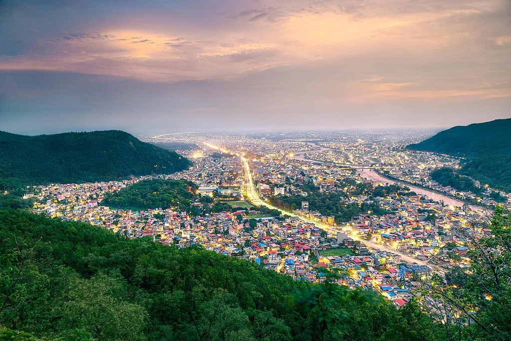
Butwal (Nepali: बुटवल), officially Butwal Sub-Metropolitan City (Nepali: बुटवल उपमहानगरपालिका), previously known as Khasyauli (Nepali: खस्यौली), is a sub-metropolitan city and economic hub in Lumbini Province in West Nepal. As of 2021, Butwal has a city population of 195,054.[1]
Butwal
 Aerial view of Butwal
| Native name | बुटवल |
|---|---|
| Official name | Butwal Sub-Metropolitan City |
| Country | Nepal |
| Province | Lumbini Province |
| District | Rupandehi District |
| Coordinates | 27.70°N, 83.45°E (approx.) |
| Established | 2 December 2014 (as Sub-Metropolitan) |
| Area | ≈ 101.61 km² |
| Elevation | ≈ 150–300 m (490–984 ft) |
| Population (2021) | 195,054 |
| Time zone | UTC+5:45 (Nepal Time) |
| Mayor | Khel Raj Pandey (NC) |
| Region | Butwal–Tilottama–Bhairahawa–Devdaha urban corridor |
| Known for | Trade hub, transport junction, Siddhartha & Mahendra Highways, Tinau River |
Geography and Administration
The city is one of the tetra-cities of rapidly growing Butwal-Tilottama-Bhairahawa-Devdaha urban agglomeration primarily based on the Siddhartha Highway in West Nepal with a total urban agglomerated population of 4,74,541. It is one of the fastest-growing cities in Nepal for health, education, construction, communication, trade, and banking sectors. It has highway connections to the Indian border at Sunauli and to the hilly towns in Tansen and Pokhara valley, and holds the title of being “The Best City in Nepal” five times in a row.
Geographically, Butwal is at the intersection of Nepal’s two different National Highways, Mahendra Highway and Siddhartha Highway. It connects western Nepal with the capital Kathmandu through the highway and air links (via Gautam Buddha International Airport at Siddharthanagar). The city stands beside the bank of Tinau River, and at the northern edge of the Terai plain below the Siwalik Hills. Its name, Butwal was derived from Batauli Bazaar , the town’s oldest residential area which is located on the western bank of the Tinau River.
Butwal was officially declared as a sub-metropolitan city on 2 December 2014 AD by combining two neighboring VDCs Motipur and Semlar. The sub-metropolitan city is currently headed by Nepali Congress leader Khel Raj Pandey.
History
Prehistory
Fossils of ancient hominoids Ramapithecus were found near the Tinau (Tilottama) River, also known as paari Butwal, as early as 1932, including a 10.1-million-year-old tooth.
Medieval history
In medieval time Butwal was known as Khasauli as it was believed to be established by Khas king. Later after the collapse of the Khasa empire it was ruled by the Sen kings of Palpa when it developed as a trading point between hilly people and plain people. In the 17th century Palpa with Butwal was annexed by Gorkha Empire. Butwal was also a place where a major battle of the Anglo-Nepalese war was fought i.e. Battle of Jitgadi Fort where the Gorkha army led by Ujir Singh Thapa beat the British forces.
Modern history
The area was a loose settlement that acted as a trading post between the hilly districts of the Lumbini zone and the Indian plains. Thus, historically Butwal connected Nepali Pahari people with their Indian neighbors. As the British East India Company annexed Awadh from its hereditary rulers while the Shah Dynasty attempted to annex the Terai, Butwal became one of the bones of contention leading to the Gurkha War 1814–16 AD.[7][8]
When King Tribhuvan fled to India in 1950 during the revolt against the Rana dynasty he traveled through Butwal. Then it was little more than a village on the western bank of Tilottama River (also known as Tinau).
Butwal is a relatively newly urbanized area, emerging and growing rapidly only since 1960 AD. With the completion of the Siddhartha Highway (H10) in 1968 AD, starting from the border at Sunauli through Butwal to Pokhara and then in1990s Mahendra Highway(H01) across the full east–west expanse of Nepal’s Terai. Butwal has made tremendous progress in the country.